| Name | Confirmed | Notes |
| Tone | Yes | Tone's cell phone # is (805) ˝˝˝-˝˝˝˝. |
| Tim | Yes | |
| Ari | ??? | |
| Wedge | No | Copco House # is (530) ˝˝˝-˝˝˝˝ |
|
Caswell Memorial State Park http://www.parks.ca.gov/default.asp?page_id=557 28000 South Austin Road Ripon CA 95366 (209) 599-3810 |
|
Durham Ferry State Recreational Area (209) 953-8800 |
| Agenda | ||
| Date | Time | Event |
| Fri(Sep 20) | 6:00pm | Tim and Tone drive up to outside Modesto. Camp out. |
| Sat(Sep 21) | morning | Tim and Tone drive to Lassen. Ari meets us there.(?) |
| Sun(Sep 22) | ||
| Mon(Sep 23) | ||
| Tues(Sep 24) | morning | Strike camp, then head home. |
| Trail head elevation | 8, 500 feet |
| Peak Elevation | 10,453 ft. |
| Distance | ~5 miles round trip |
| Grade | steady 15% |
| Time (average) | 4 hours |
| Best time for hiking and car touring | August and September. |
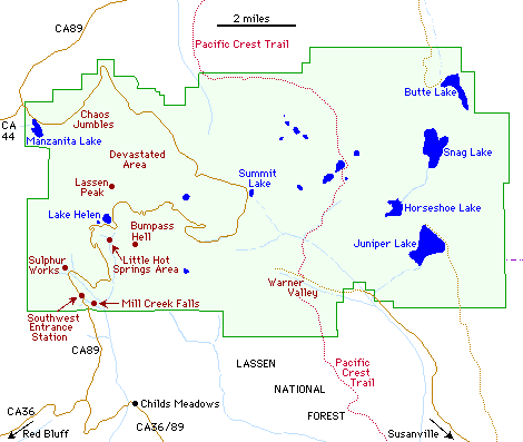
Wedge left us a surprise:

your surprise is waiting at the monument at the end of the trail at lassen. it is at the
back of the monument under the rocks. this is a monument that is a
rectangle with info on top.

the trail continues, and you can hike a few hundred yards more but this
is where the stuff is
Brokeoff Mountain - Start at the turnout .25 miles south of SW entrance, the round trip distance is about 7.4 miles and takes approximately 5 hours. It is a steady uphill climb of 2,600 feet with views, wildflowers, and streams along the way.
Mill Creek Falls - Start at the southwest campground and the trail is about 4.6 miles for the round trip and takes approximately 2.5 hours. The terrain is about a 300 foot uphill or downhill walk through wildflowers and forests to the highest waterfall in the park.
Lily Pond Nature Trail - Begins at the Loomis Museum Parking Area and the round trip takes about 1 hour with an easy walk of 1 mile round trip through forests and around beautiful mountain lakes.
Bumpass Hell Trail - Start at the parking area 6 miles from SW entrance or 23 miles from the north entrance for a gradual climb of about 500 feet for the first mile, then descend into the largest thermal area in the park. Hot springs, steam vents, and mudpots are featured on this 3 mile round trip hike that takes approximately 3 hours.
Lassen Peak Trail - The trailhead begins at the parking area 7 miles from the SW entrance or 22 miles from the north entrance. The 2,000 foot climb with an uphill grade of about 15% begins at 8,500 feet and takes about 4.5 hours for the round trip of approximately 5 miles. Views of recent volcanic activity, craters, and panoramic vistas greet you at the top.
Terrace, Shadow & Cliff Lakes - The 3 miles total round trip for visiting these mountain lakes takes about 3 hours and begins at the turnout 9 miles from the SW entrance or 21 miles from the north entrance. The trail leads downhill 300 feet to Terrace Lake, 350 feet to Shadow Lake, and 650 feet to Cliff Lake through wildflowers and forests. Remember, its uphill on the return trip.
King Creek Falls - This hike is "specially designed" for photographers! Cascading waterfalls, abundant wildflowers, and natures beauty abound on this trail that begins at the turnout 12 miles from the SW entrance or 17 miles from the north entrance. A 700 foot descent on a 3 mile round trip trail takes about 2.5 hours.
Summit Lake to Echo & Twin Lakes - Start at the east side of Summit Lake using the trail that encircles the lake. Echo Lake is 4 miles, Upper Twin Lake is 7 miles, and Lower Twin Lake is 8 miles round trip taking about 6 hours total time for the round trip. This is a great spot for overnighters and summer swimming!
Manzanita Lake - Its about a 1.6 mile hike around the lakeshore that takes about 1.5 hours traveling over level ground. Wildlife, flowers, trees, and shrubs line this scenic hike.
Cinder Cone - Begin at the west end of Butte Lake Campground for this fairly steep 800 foot climb through loose cinders. Be sure to wear sturdy boots on your 4 mile round trip hike to the cone summit and back. Allow 3 hours for the climb with an extra hour to explore the trail down the south slope. Geologists and photographers will enjoy this scenic trail.
Boiling springs Lake - This easy 200 foot hike takes about 2 hours for the round trip, traveling 3 miles past mudpots, wildflowers, and forests to the lake and back. Your hike begins at the parking area west of Warner Valley Campground.
Mt. Harkness - A historic fire lookout is the destination on this scenic 4 mile round trip hike with an enjoyable 1,300 foot climb that takes on the average of 4 hours. The trailhead begins at the southeast end of Juniper Lake Campground.
| Trail | Start | Distance | Time | Terrain | Features |
| Boiling Springs Lake | Parking area west of Warner Valley Campground | 3.0 mi | 2.0 hrs | Easy 200 ft climb | Mud-pots, flowers, forests, trail leaflet |
| Brokeoff Mountain | Road Marker 2 | 7.4 mi | 5.0 hrs | Uphill, steady 2,600 ft climb | Scenic, flowers, streams |
| Bumpass Hell | Parking area by Road Marker 17 | 3.0 mi | 3.0 hrs | Gradual 500 ft climb first mile, 250 ft descent into thermal area | Largest thermal area, hot springs, steam vents, mud-pots. Stay on established trail |
| Cinder Cone | West end of Butte Lake Campground | 4.0 (5.0 if trail followed down So. side of cone) mi | 3.0, 4.0 hrs | 800 ft climb, fairly steep with loose cinders | Forest, scenic, wear high shoes or boots, for geologist & photographers |
| Kings Creek Falls | Road Marker 32 | 3.0 mi | 2.5 hrs | 700 ft descent | Cascade, forest, flowers, for photographers |
| Lassen Peak | Parking lot by Road Marker 22 | 5.0 mi | 4.5 hrs | 2,000 ft uphill on steady, steep grade (15%) begins at 8,500 | Recent volcanic activity, timberline trees, bring water and jacket, watch for lightning |
| Lily Pond Nature Trail | Loomis Museum Parking Area | 1.0 mi | 1.0 hr | Easy Walk | Lakeshores, forest |
| Manzanita Lake | Any place Manzanita | 1.6 mi around lakeshore | 1.5 hrs | Level, pleasant walk | Lake, flowers, wildlife, trees, shrubs, scenic |
| Mill Creek Falls | Southwest Campground | 4.6 mi | 2.5 hrs | Downhill about 300 ft, uphill about same | Highest waterfall, forest, flowers |
| Mt. Harkness | Southeast end of Juniper Lake Campground | 4.0 mi | 4.0 hrs | Enjoyable 1,300 ft climb | Scenic, flowers, historic fire lookout |
| Summit Lake to Echo & Twin Lakes | East side of Summit Lake, from trail encircling lake | 8.0 total, (Echo Lake 4, Upper Twin 7, Lower Twin 8) mi | 6.0 (Echo 3, Upper Twin 5, Lower Twin 6) hrs | 500 ft uphill first mi, descending 500 ft to Lower Twin | Lakes, forest, flowers, good for overnighters, summer swimming |
| Terrace Shadow & Cliff Lakes | Road Maker 27 | 3.0 total (Terrace 0.5, Shadow 0.8, Cliff 1.5) mi | 3.0 (Terrace 1, Shadow 1.5, Cliff 3) hrs | Downhill, 300 ft to Terrace, 350 ft to Shadow, 650 ft to Cliff; uphill on return | Forest, lake, flowers |
| Campground | Open | Close | Sites | Toilets | Firepits & Tables | Water | Fees | Notes |
| Summit Lake South | Jun | Sep 23rd | 48 | Flush | Yes | Yes | $12.00 | Elev 6695 ft, located 12.0 mi from Manzanita Lake, 17.5 mi from Southwest Entrance Station |
| Manzanita Lake | May | Sep 23rd w/ water ( after w/o water ) | 179 | Flush | Yes | Yes | $14.00 | Elev 5890 ft, located adjacent to and so. of Manzanita Lake, showers, dump station, motorless boats, trailers to 35 ft |
| Warner Valley | Jun | Oct 1st w/ water ( after w/o water ) | 18 | Pit | Yes | Yes | $12.00 | Elev 5650 ft, located 1.0 mi west of Warner Ranger Station, via dirt road 17.0 mi out of Chester. Trailers not recommended |
| Southwest (walkin) | May | Sep 23rd w/ water ( after w/o water ) | 21 | Flush | Yes | Yes | $12.00 | Elev 6700 ft, walk-in campsites, located east side of Lassen Chalet parking area, near Southwest Entrance Station |